Cities and transit agencies are finally getting on board with bus stop data
Cities and transit agencies are finally getting on board with bus stop data
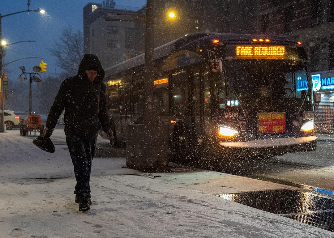
It was the that New York City had seen in a decade ŌĆö but the city was ready. This winter, the NYC Department of Sanitation took a new approach to clearing snow for bus riders and pedestrians. After January flurries blanketed the city, DSNY , geotagging every unsheltered bus stop and crosswalk.
ŌĆ£ItŌĆÖs literally dots on a map, and the dot is color-coded based on whether itŌĆÖs been certified clear or not,ŌĆØ Joshua Goodman, spokesperson for the department, told .
This new app allowed DSNY to rapidly clear bus stops and crosswalks. The department has cleared pedestrian infrastructure in the past, but not kept track of its work in any systematic way, despite being a data-driven enterprise.
ŌĆ£The idea of not having data about, for example, when trash has been collected on a given block is ridiculous and upsetting to us,ŌĆØ says Goodman. ŌĆ£And yet, for this, it really took that big storm and the fresh eyes of the new administration to push us forward.ŌĆØ
In New York, as in many other cities, are responsible for and curb ramps, meaning that responsibility for unsheltered bus stops (usually just a pole with a sign) is split across thousands of different people or businesses.
A patchwork of responsibility can mean a patchwork of accessible and inaccessible sidewalks and bus stops.
ŌĆ£What weŌĆÖre really focused on is just making sure that New Yorkers can get where they need to go when they need to go there,ŌĆØ says Goodman.
ItŌĆÖs not just snow. Cities and transit agencies can use data to make bus stops safe and accessible. Transit agencies, including the Massachusetts Bay Transportation Authority, are working to standardize data for bus transit amenities, including shelters, bathrooms, escalators, and lighting, which could mean a better, more consistent experience for bus riders.
For the MBTA, bus stop data started with accessibility
Almost a decade ago, Laura Brelsford and her team started on an ambitious project to rigorously catalog all of roughly 7,000 bus stops in the MBTA system.
ŌĆ£We didnŌĆÖt just look at the bus stop proper,ŌĆØ says Brelsford, assistant general manager of system-wide accessibility. ŌĆ£We looked at [questions like], do you have an accessible crossing to get from one side of the street to the other to reach the bus stop? What are the curb ramps like adjacent to the bus stop?ŌĆØ
Through this process, the MBTA was able to identify and remedy most of the 280 stops identified as completely inaccessible.
It wasnŌĆÖt easy. The majority of bus stops ŌĆö 99% ŌĆö fall outside of the MBTAŌĆÖs jurisdiction.
ŌĆ£We use that data to try to identify where we needed to invest in upgrades and where we needed to push municipalities to make improvements to their infrastructure,ŌĆØ says Brelsford.
Importantly, the agency has made accessible bus stops a priority, investing its own capital improvement funds into upgrades, with funding also coming from state grants and .
Cataloging bus stops can be the first step to prioritizing and implementing improvements ŌĆö but what if the data could be shared with bus riders planning their trips?
Since 2018, the MBTA has been publishing data on facilities within the system, with the focus mostly on train station accessibility.
ŌĆ£You could search for a train station and see, okay, what kind of platform is this? Is this platform low level? Is it high level? Depending on my accessibility needs, will it work for me?ŌĆØ says Josh Fabian, deputy director of transit technology for the MBTA.
The industry-wide standard for transit data, (General Transit Feed Specification), allows transit agencies and trip-planning apps to speak the same language about schedules and stops. But so far, GTFS hasnŌĆÖt included information about station or stop amenities: Is there a bathroom? Does the bus stop have a place to sit down? Is the train platform accessible?
While many transit agencies have been tracking and maintaining that data for their own purposes, there is currently no uniform way to share that data via GTFS. Now, Fabian and other transit data experts are working to that would allow transit agencies to provide this data to riders through apps like Transit or Google Maps.
The effort to incorporate bus stop and transit station amenities into the data standard is still in the early stages.
GTFS is open source, and adding new parameters is a community effort. Stephen Miller, policy lead at Transit, explains that in order for new parameters to be adopted, there must be a producer (transit agency) creating the data and a consumer (an app) that will use the data.
ŌĆ£You have to have both a producer and a consumer demonstrate that it works, that itŌĆÖs live, and then the community votes to say, ŌĆśOkay, do we want this to just be kind of like a test, or do we actually want to integrate this into GTFS?ŌĆÖŌĆØ Miller says.
Adding this feature could improve the customer experience by alerting transit riders to the presence of bus shelters or bathrooms, for example, while also making it easier for transit agencies and cities to maintain and upgrade existing infrastructure.
Bus stop data as a two-way street
In some transit systems, bus riders themselves are providing valuable data to help local governments address accessibility and maintenance issues.
In Santa Monica, California, Big Blue Bus riders can use TransitŌĆÖs feature to alert the agency when bus stops are dirty.
ŌĆ£We were able to identify, OK, what are the top stops that are consistently getting people saying, thereŌĆÖs litter and trash here. And the city of Santa Monica sent out crews to those stops to clean them up,ŌĆØ says Miller. ŌĆ£ItŌĆÖs about temperature-taking, as opposed to somebody being so mad or having enough time to be mad to fill out the form or call 311.ŌĆØ
ItŌĆÖs worth noting that thereŌĆÖs an unusual overlap between Big Blue Bus, the transit agency, and Santa Monica, the city, which might explain this level of service. And itŌĆÖs not just transit agencies and cities that are leveraging data to improve the bus rider experience. In Vancouver ŌĆö where to identify which bus stop poles need solar-powered lights ŌĆöbus bench activists are using Transit data to push cities to .
So far, 19 transit agencies out of 180 transit partners are using the appŌĆÖs Rate-My-Ride feature. And while cities are also interested in partnering with Transit, no partnerships have yet been formalized, Miller says.
Transit has, however, been working with transit agencies like the MBTA to integrate stop amenity data into GTFS. In the future, the app could also share crowd-sourced data using the same standard.
ŌĆ£We started producing crowdsourced data about stop amenities. The MBTA had already put together its own inventory. So, those discussions started to come together,ŌĆØ says Miller.
The goal, according to Miller, is not to have one data standard for all city infrastructure ŌĆö to lump bus shelters with curb ramps, for example ŌĆö but to make it possible for different stakeholders within the public right-of-way to share and integrate data.
The politics of bus stop data
New York CityŌĆÖs pedestrian infrastructure app shows that cities donŌĆÖt have to wait to make streets safe and accessible for people walking, rolling, and taking the bus. But in a landscape where the city manages bus stops, not the transit agency, passing the buck can become the norm.
ŌĆ£Since bus stop amenities and sidewalk rights-of-way are controlled by local municipalities, Metro does not currently use this information as part of operations,ŌĆØ LA Metro told Next City in an emailed statement, noting that city planners can use Google Street View to visualize a better bus stop as part of its tool. Although the agency conducted an analysis of all 12,000 bus stops in its system, that data is not publicly available.
Bus riders donŌĆÖt care who controls a bus stop ŌĆö they care about getting where they need to go. To prioritize the bus rider experience, cities, transit agencies and tech companies must work together to fix obstacles, Miller believes.
ŌĆ£If the cityŌĆÖs orientation only exists to please the whims of various councilmembers who have political power, or the transit agency is oriented around, ŌĆśWe need to get the buses out, get the buses back,ŌĆÖ and thatŌĆÖs it, then theyŌĆÖre not going to be aligned to solve those issues,ŌĆØ he says.
Historically, bus riders have been treated as second-class citizens, meaning fewer amenities like . Some cities, like Los Angeles, have allowed homeowners and city council members or .
Creating a unified data standard wonŌĆÖt force transit agencies and cities to prioritize the bus rider experience ŌĆö but itŌĆÖs a start.
In California, lawmakers have to create a statewide data registry for transit stops.
ŌĆ£What we have now is fragmented and inconsistent data, and thatŌĆÖs not fun for anyone,ŌĆØ said Eli Lipmen, executive director of Move LA, addressing the . ŌĆ£Transit stop names, locations, identifiers can vary across different agencies, across different datasets, and it creates confusion.ŌĆØ
of the Civil Rights Act dictates that transit agencies must provide equal access to transit amenities across the system. Integrating data standards could help compare transit stop amenities between agencies and neighborhoods, highlighting gaps.
Coordination between transit agencies and cities is still a ŌĆ£work in progress,ŌĆØ says Brelsford. ŌĆ£ItŌĆÖs not always clear to riders who should be doing what and what to expect.ŌĆØ
This story was produced with support from the Solutions Journalism NetworkŌĆÖs How Government Responds Innovation Fund.
was produced by , a nonprofit newsroom covering solutions for equitable cities, and reviewed and distributed by ┬ķČ╣įŁ┤┤.